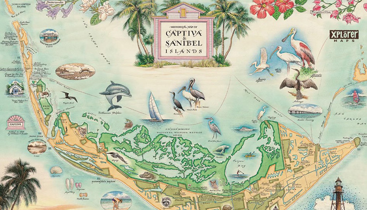
Xplorer Maps, a Missoula, Montana-based creator of custom hand-drawn maps available on a variety of gift and decor items, is donating 50% from all online sales of any of its Sanibel-Captiva-related products, which includes blankets, puzzles, drinkware, tote bags, maps, and more, to the FISH Foundation, an on-island organization of "neighbors helping neighbors."
The fundraiser is retroactive to Oct 1, and continuing through the entire month of October. Products are available at https://xplorermaps.com/collections/sanibel-captiva-islands
“While we are literally thousands of miles away, tucked into our little corner in the mountains of western Montana, we feel compelled to act the best we know how and would like to contribute in some small (but genuinely meaningful way) to the ongoing relief efforts now underway on Sanibel-Captiva,” the company announced in its blog, https://xplorermaps.com/blogs/xm-blog/q3-quarterly-xplorer.
According to Greg Robitaille, CEO, Xplorer Maps, the company has had a long-standing relationship with the area. “Back in 2015, the Captiva Island Historical Society commissioned Xplorer Maps to create an original and custom hand-drawn map of Sanibel & Captiva Islands. As a result of that collaborative partnership and through the sale of limited edition signed and numbered giclee art prints, Xplorer Maps has donated almost $40,000 to the CIHS to help with their conservation, preservation and education outreach efforts on the island.”
Robitaille adds, “Since that time, the residents, businesses, visitors and everything that happens around that amazing slice of paradise on Florida's Gulf Coast have been an important part of our Xplorer Maps ‘family’ — always on our minds and always supporting each other. Like so many others from coast to coast, we are so saddened by the news of the massive disruption, destruction, and devastation caused by Hurricane Ian … on so many residents and businesses that call the islands home.”